Miami · FAA Part 107 Licensed & Insured
Drone Inspections in Construction: Safer, Faster Site Monitoring
Drone inspections in construction use an FAA Part 107 pilot and a camera drone to document roofs, facades, deck edges, and structure without putting anyone at height. On a Miami jobsite that means a full visual record in hours instead of a day, delivered as photographs, video, orthomosaic maps, and 3D models your team can measure and compare.
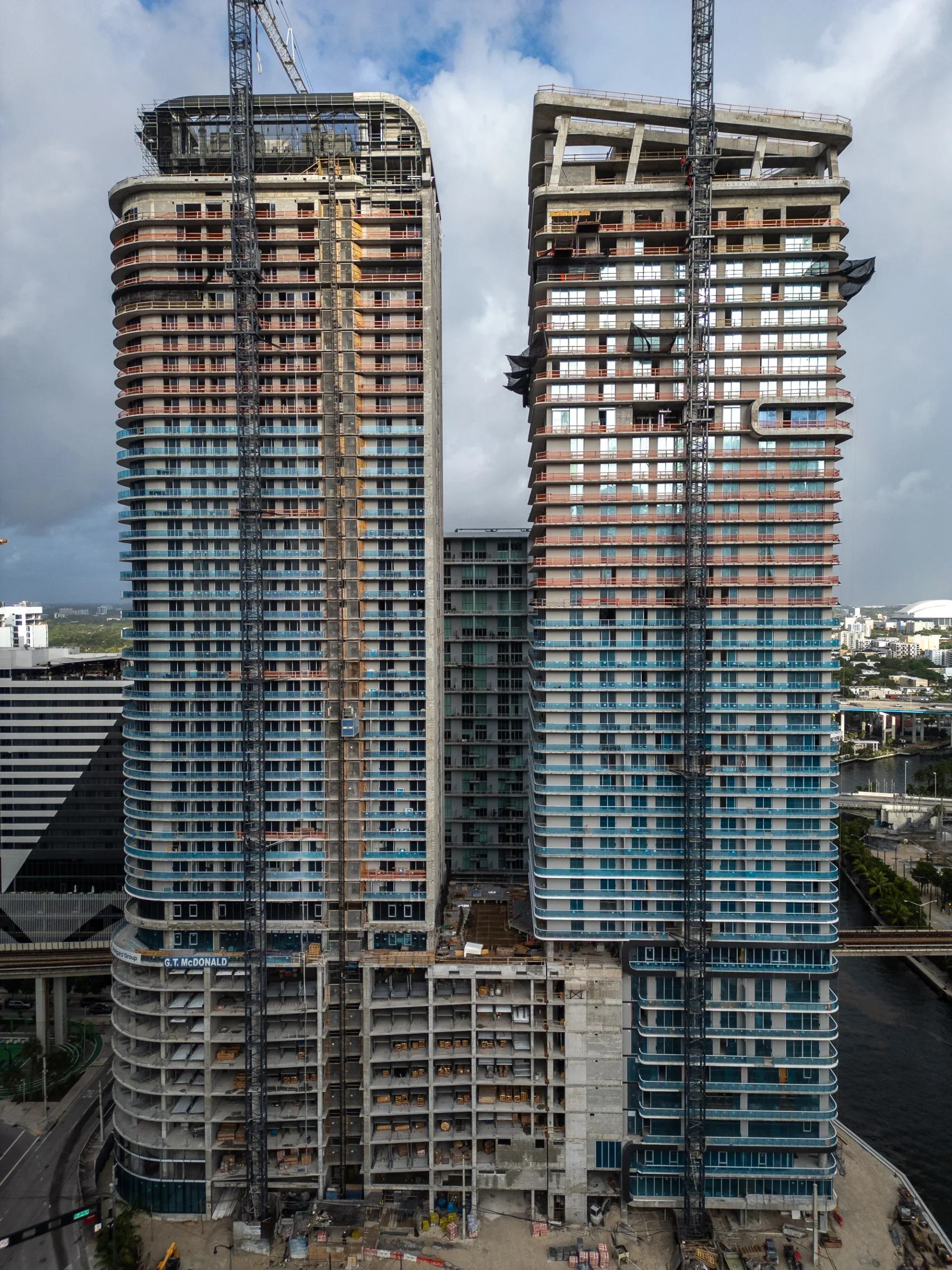
Above: Aston Martin Residences at the mouth of the Miami River in Brickell, photographed from the air at sunrise.
A construction site is one of the few workplaces where the thing you most need to look at is also the most dangerous place to stand. Roof edges, parapets, curtain wall joints, the twentieth floor deck before the guardrail goes up. Traditional inspection sends a person there. Drone inspections in construction send a camera instead, and we have documented exactly those conditions from the air on Aston Martin Residences, Waldorf Astoria Residences Miami, The Standard Residences in Brickell, Baccarat Residences, and Grand Hyatt Miami Beach without anyone climbing for the picture.
Key Takeaways
- Drone inspections in construction replace the climb, not the judgment. A Part 107 pilot flies the roof, facade, and deck edge while your crew stays on the ground.
- A site that took a full day to walk and photograph is usually captured in a couple of hours, and the same flight path repeats on every visit so the images actually compare.
- You get working files, not just nice pictures: orthomosaic GeoTIFF, point cloud in LAS or LAZ, 3D model in OBJ or FBX, DXF contours, volume reports, a photo set, and a web viewer link.
- With ground control points, expect roughly 2 to 4 cm horizontal and 3 to 6 cm vertical accuracy. That is enough for progress and quantity tracking, and it is not a replacement for a Florida licensed surveyor.
- Almost every Miami jobsite sits under controlled airspace, so LAANC authorization is part of the job. We clear it before the flight date, not on the morning of.
Recent Work
What Does Drone Construction Documentation Actually Look Like?
This is a topping off at The Standard Residences in Brickell, filmed as part of a running construction update. The same flight discipline that produces a clean ceremony video produces a clean inspection set: planned paths, consistent altitudes, repeatable angles. If footage looks improvised, it was, and improvised footage will not compare month to month.

The Standard Residences, Brickell, Miami. Topping off ceremony and construction update, January 2026. Aerial and ground coverage by one crew.
Why the milestone video and the inspection set come from the same flight
Most jobs need both. The owner wants something to send investors and the press. The project team wants a dated record of what the building looked like the week the slab went in. Sending two vendors to an active site means two safety briefings, two airspace requests, and two sets of images that do not line up.
We fly it once. The marketing edit and the documentation set come out of the same mission, which is the practical reason the ceremony coverage and the progress coverage sit on the same page.
See video production in Florida or drone services for construction.
What Is a Drone Inspection in Construction?
A drone inspection in construction is a planned flight over an active site that captures the roof, facade, deck edges, and structure in high resolution so nobody has to climb to see them. The output is a dated visual record: photographs, video, an orthomosaic map of the whole site, and where the job calls for it, a point cloud or 3D model.
The word inspection does a lot of work here, so it is worth being precise. A drone collects the evidence. A person still interprets it. On a progress flight, that person is your superintendent or owner's representative. On a structural assessment, it is a licensed engineer. The aircraft does not sign anything.
What changes is access. A camera that can hold position forty feet off a parapet at the fortieth floor sees the sealant line, the flashing, the spalling, and the staged material better than a person leaning over a guardrail, and it gets there in minutes instead of after a swing stage permit.
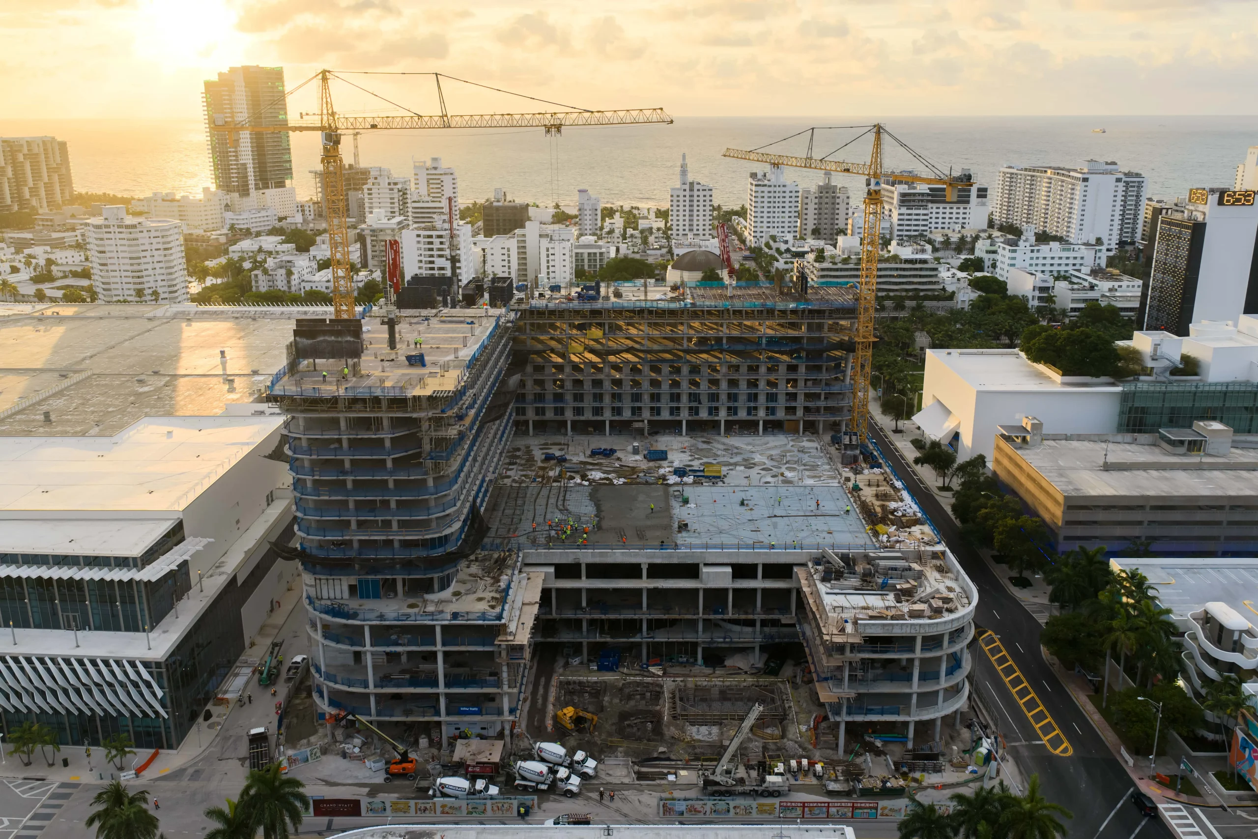
Grand Hyatt, Miami Beach. A single elevated frame like this shows roof condition, deck staging, crane position, and how the structure meets its neighbors. From the ground you would need a dozen photographs and still miss the roof.
The Return on Coverage
What Your Team Actually Walks Away With
Your superintendent answers the question without sending anyone up. Your owner and lender get a dated record they can trust. Your project manager gets images from this Thursday that line up with images from three Thursdays ago. That is the return: fewer people at height, faster answers, and documentation that already exists on the day someone disputes a date.
Nobody at the edge
Roofs, parapets, facades, and unfinished decks get documented without a person standing on them. The safety case is the reason most teams call the first time.
Hours, not days
One planned mission covers what a walking survey covers, and covers the parts a walking survey cannot reach at all. Your crew keeps working while it happens.
A record that holds up
Dated, high resolution imagery of exactly what the site looked like. Useful for owner reporting, lender draws, insurance, and any conversation that starts with "when did that happen."
Progress you can compare
Repeat the same flight path each visit and you get a visual timeline instead of a folder of unrelated photos. Problems show up as a change, which is how people actually notice them.
From Active Sites
What the Camera Gets on a Miami Jobsite
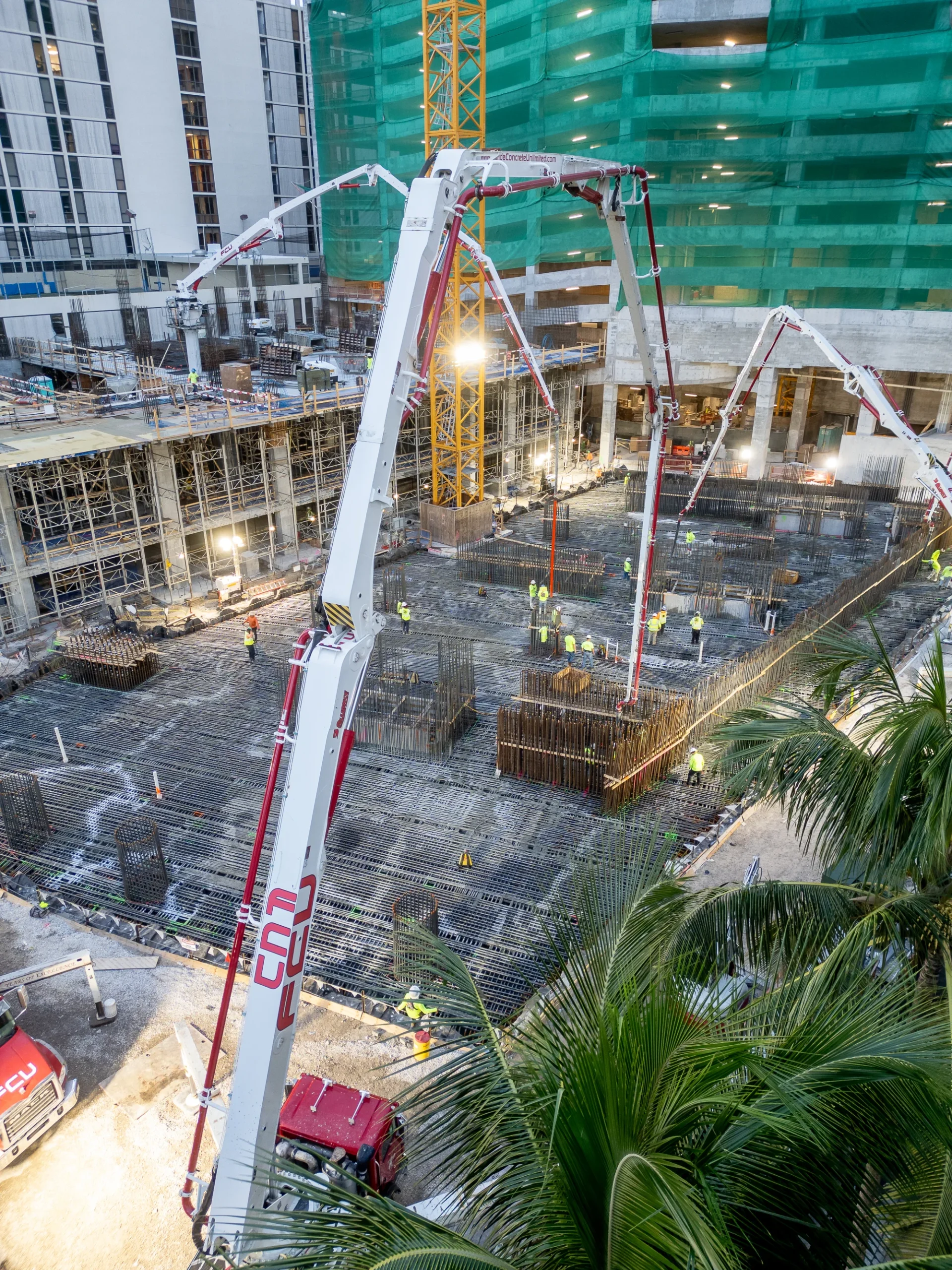
These frames come from active South Florida projects, from a foundation pour to finished towers on the Miami River. They are here to show what the camera actually returns: edge conditions, glazing lines, staging, crane position, and how a building sits against everything around it. Click any image to enlarge it.

What Does a Complete Drone Inspection Include?
A complete drone inspection is more than one lap around the building. It combines close orbit stills of the facade and roof, a nadir grid flight that builds the orthomosaic, a photogrammetry set for the point cloud and 3D model, and repeat frames from fixed points so this month lines up against last month.
| Capture method | What it captures | Best for |
|---|---|---|
| Close orbit stills | Facade, glazing, sealant lines, parapets, roof surface, deck edge conditions | Punch list items, defect documentation, facade and roof review |
| Nadir grid flight | Orthomosaic map of the full site as a GeoTIFF, to scale | Progress overlays, site logistics planning, area takeoffs |
| Photogrammetry set | Point cloud in LAS or LAZ and a 3D model in OBJ or FBX | Comparison against the model, volumes, remote walkthroughs |
| Fixed point repeat flight | The same frames, same altitudes, same angles, every visit | Week over week and month over month progress comparison |
| Aerial and ground video | A walkthrough of the site as it stands, cut and finished | OAC meetings, lender and investor updates, project reels |
| Ground and interior photography | Everything the aircraft cannot reach, shot on the same visit | A complete record when the roof is only half the story |
Standard deliverables include the orthomosaic GeoTIFF, 3D model, point cloud, DXF contour files, a volume report as CSV or PDF, the full photo set as JPEGs, and a web viewer link. For volumes, cut and fill, and CAD ready contours, see Miami drone mapping and our drone mapping services. For the stills side, see aerial photography services.
Drone Inspection or Traditional Access: Which Does the Job?
Traditional access still wins whenever somebody has to touch the building: a hammer sounding, a moisture reading, a core sample, a repair. It loses on everything visual. A swing stage takes days to permit and rig, a lift needs ground and often a lane closure, and a roof walk puts a person on a live edge. The drone does the looking.
| Traditional method | The friction | What the flight does instead |
|---|---|---|
| Swing stage or suspended scaffold | Rigging, permits, engineering sign off, and days of lead time before anyone sees anything | Same elevation, same detail, flown the same morning you call it in |
| Boom lift or man lift | Needs stable ground, clearance, and sometimes a street closure. Limited reach on a tall tower | No ground footprint, no reach limit within legal altitude, no lane closure |
| Roof and parapet walk | Fall exposure at exactly the condition you are trying to inspect | The camera goes over the edge instead of a person |
| Ground level photography | Foreshortened, blocked by fencing and staging, and the roof is invisible | Plan view and elevation view of the entire site in one visit |
| Full walking survey with a camera | A day or more of somebody's time, and the photos rarely repeat from visit to visit | A repeatable mission that produces a comparable set every time |
| Hands on testing and sampling | Slow and disruptive, and there is no alternative | Nothing. This is what the drone does not replace, and we will say so |
How Do We Fly an Active Jobsite Without Slowing It Down?
We work around your sequence instead of against it. The pilot arrives in PPE, signs in with the superintendent, walks the site, and agrees a launch and recovery point clear of the crane radius and the delivery route. Airspace is already cleared before the date. Nothing has to stop, and most days nobody outside the trailer notices the flight happened.
We know construction
PPE on site, sign in at the trailer, and a pilot who understands crane operations, pick paths, and why you do not launch under a load.
We clear the airspace first
LAANC authorization is requested ahead of the flight date, not improvised on the morning of the shoot.
We coordinate with the super
Five minutes with the superintendent before takeoff sets the launch point, the no fly zones on the deck, and who to call on the radio.
One crew, one visit
Air, ground, sound, and editing come from the same team, so one safety briefing covers the whole capture.
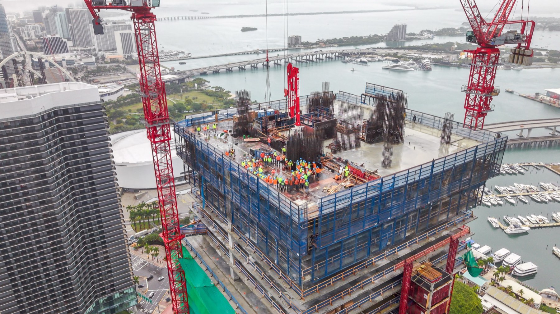
Waldorf Astoria Residences Miami, topping out. Crews on the top floor at the moment the structure tops out. This is exactly the condition drone inspection is built for: an open deck, no permanent guardrail, and a view no one should have to lean over an edge to get.
How a drone inspection runs, start to finish
1. Planning
We review the site, the objective, the crane and airspace situation, and file the LAANC authorization. You get a flight window, not a maybe.
2. Flight
A Part 107 certificated pilot flies the planned path. Orbits, grid, and fixed points, in one visit, with the site running.
3. Processing
Images become the orthomosaic, point cloud, model, and photo set. Video is cut. Anything flagged in the air gets called out.
4. Delivery
Files land in formats your team already opens, plus a web viewer link so people who do not run CAD can still look.
The Miami Question Nobody Answers
Do You Need a Permit to Fly a Drone Over a Miami Jobsite?
You do not need a permit to have a drone flown over your own jobsite, but the pilot does need credentials. Commercial flights require an FAA Part 107 certificated remote pilot and a Remote ID equipped aircraft. Most of Miami-Dade sits under controlled airspace from Miami International, Opa-locka, and Miami Executive, so the flight also needs LAANC authorization.
LAANC is the FAA system that grants near real time authorization to fly in controlled airspace, up to a published ceiling that changes grid square by grid square. Downtown, Brickell, and the areas near the airports carry low ceilings, and a request above the published grid altitude is not automatic. It goes to further coordination and it takes time. This is the single most common reason a jobsite shoot gets rescheduled at the last minute, and it is entirely avoidable by asking early.
Part 107 also sets the operating rules that shape what a flight can and cannot do: a 400 foot altitude limit, with an allowance to fly within 400 feet of a structure, minimum flight visibility of three statute miles, and the requirement to keep the aircraft in sight. Flights over people and moving vehicles are restricted, which is a real consideration on a site with an active crew and a public sidewalk on two sides. We plan around all of it before the date.
Florida law adds a second layer. Statute 934.50 makes it unlawful to use a drone with an imaging device to record privately owned property or its occupants with the intent to conduct surveillance where there is a reasonable expectation of privacy. Documenting the site you control is not surveillance. Pointing a long lens into the neighboring tower's balconies is a different matter, and we plan flight paths so it does not happen.
Can a Drone Replace a Florida Milestone Inspection?
No. Florida Statute 553.899 requires a milestone inspection to be performed by a licensed architect or engineer authorized to practice in the state, and phase one is a visual examination of the building's structural components with a qualitative assessment. A drone does not replace that professional, and any provider who implies otherwise is selling you a problem.
What aerial documentation does is get that engineer's eyes onto a roof, a parapet, or a fortieth floor balcony line without a swing stage, and hand them dated high resolution imagery to work from before and after they go up themselves. On condominium buildings three stories or more, the milestone requirement lands at 30 years of age, or 25 years within three miles of the coastline, and then every ten years. In South Florida that is a very large number of buildings, and the access cost is the part everyone underestimates.
The same boundary applies on the measurement side. Drone photogrammetry with ground control points delivers roughly 2 to 4 cm horizontal and 3 to 6 cm vertical accuracy, which is genuinely useful for progress tracking, stockpile volumes, and quantity checks. It is not a boundary survey, a topographic survey, or an engineering certification. Anything going to a legal, boundary, or engineering use needs a Florida licensed surveyor, and we work alongside one rather than around one.
Miami Projects We Have Documented From the Air
The projects below are ones we have flown. Aston Martin Residences, Waldorf Astoria Residences Miami, The Standard Residences in Brickell, Baccarat Residences, Grand Hyatt Miami Beach, Cipriani Residences, and 1200 Brickell. Different stages, different problems, and the same working method: clear the airspace, brief the superintendent, fly the plan, deliver files people can open.
| Project | Location | What we documented |
|---|---|---|
| Aston Martin Residences | Miami, FL | Facade and elevation detail, sunrise context aerials over the Miami River, progress coverage |
| Waldorf Astoria Residences Miami | Miami, FL | Topping out coverage with crews on the top floor, mat pour documentation |
| The Standard Residences, Brickell | Miami, FL | Topping off ceremony and running construction updates, air and ground, single crew |
| Baccarat Residences | Miami, FL | Foundation pour, full mat and truck sequence from the air |
| Grand Hyatt | Miami Beach, FL | Construction progress documentation and site context aerials |
| Cipriani Residences | Miami, FL | Construction progress documentation |
| 1200 Brickell | Miami, FL | Office building documentation and site mapping |
Related pages: drone services for construction, drone services in Miami, and Miami drone mapping.
Drone Inspections in Construction FAQ
How accurate are drone measurements on a construction site?
With ground control points, expect roughly 2 to 4 cm horizontal and 3 to 6 cm vertical accuracy. That is accurate enough for progress tracking, stockpile volumes, cut and fill checks, and quantity verification. It is not a boundary or topographic survey. Anything headed for a legal, boundary, or engineering use needs a Florida licensed surveyor, and we work alongside one rather than around one.
Do I need a permit to fly a drone over a construction site in Miami?
You do not need a permit as the site owner, but the operator does need credentials. Commercial flights require an FAA Part 107 certificated remote pilot and a Remote ID equipped aircraft. Most of Miami-Dade sits under controlled airspace from Miami International, Opa-locka, and Miami Executive, so the flight also needs LAANC authorization. We request it before the flight date, and we tell you early if the published ceiling over your site is going to be a problem.
Can a drone inspection satisfy Florida's milestone inspection requirement?
No. Florida Statute 553.899 requires a licensed architect or engineer authorized to practice in the state to perform the milestone inspection, and phase one is a visual examination of the building's structural components. A drone does not replace that professional. What it does is give the engineer high resolution, dated imagery of roofs, parapets, and upper floor conditions without a swing stage, which usually shortens the access portion of the job considerably.
What deliverables do I receive after a drone inspection?
Typical deliverables are an orthomosaic map as a GeoTIFF, a 3D model in OBJ or FBX, a point cloud in LAS or LAZ, contour files in DXF, a volume report as CSV or PDF, the full photo set as JPEGs, and a web viewer link so people who do not run CAD can still look at the site. Video is delivered cut and finished when the scope includes it.
Can drone data be used with BIM, AutoCAD, or Revit?
Yes. Deliverables are provided in formats built to drop into the tools your team already uses. Orthomosaics come as GeoTIFF, contours as DXF, point clouds as LAS or LAZ, and models as OBJ or FBX, all of which import into AutoCAD, Revit, and the common construction platforms. If your team needs a specific format or coordinate system, tell us during planning and we will set the processing up for it.
How often should we fly the site for progress monitoring?
There is no single right cadence, and it depends on how fast the site changes. Vertical construction with monthly owner reporting usually settles into one flight a month, with additional flights booked around milestones like the mat pour, topping out, and facade close in. Sites moving earth or tracking quantities get more value from twice a month. We fly recurring schedules and repeat the same flight path each visit so the images line up.
What happens if the weather is bad on the scheduled day?
Flights are weather dependent. Sustained wind, heavy rain, and low visibility stop operations, and wind at 400 feet is often very different from wind at street level. We watch the forecast and the winds aloft and make the call early rather than sending a crew to a site that cannot be flown, then reschedule to the next workable window. Miami's rainy season and the June through November hurricane season both call for more schedule flexibility.
Does work have to stop while the drone is flying?
In most cases no. The pilot signs in, briefs with the superintendent, and sets a launch and recovery point clear of the crane radius and the delivery route. Part 107 restricts flight over people and moving vehicles, so the flight path is planned around where the crew is working rather than the crew being planned around the flight. Brief pauses are occasionally worth it for a specific shot, and that is always agreed in advance, never assumed.
Is it legal to record a construction site and the surrounding property from the air in Florida?
Documenting the site you own or control is legal. Florida Statute 934.50 makes it unlawful to use a drone with an imaging device to record privately owned property or its occupants with the intent to conduct surveillance where there is a reasonable expectation of privacy. That is aimed at surveillance, not at construction documentation. We plan flight paths and camera angles so neighboring balconies, windows, and private outdoor space stay out of frame.
Are your pilots licensed and insured?
Yes. Every flight is operated by an FAA Part 107 licensed remote pilot, and our pilots are insured. We handle LAANC authorizations and waivers as part of the job rather than treating airspace as the client's problem. If your general contractor has specific insurance documentation requirements for vendors on site, raise it when you schedule so it is sorted out before the crew arrives.
Stop Sending People Up for a Photograph
Tell us the site, the stage, and what you need to see. We clear the airspace, brief your superintendent, fly it in one visit, and deliver files your team can actually open. One crew for air, ground, sound, and editing, FAA Part 107 licensed and insured.
SCHEDULE YOUR FIRST FLIGHTOr call 305-878-9689
Background: a selection of South Florida projects documented by Drone Permission.